Our Drone Packages
Application Drones
DJI Agras T100
The DJI Agras T100 represents a generational leap in agricultural technology. Built on a decade of innovation, it delivers the power and intelligence needed for the most demanding farm operations.
Massive Capacity: A 220 lb (100 kg) max payload for spraying, spreading, and lifting.
Double the Output: Engineered to work twice as fast as previous generations.
Precision Spraying: A 100L tank with dual atomizing sprinklers ensures total coverage—from the top of the canopy to the underside of the leaf.
DJI Agras T50
The DJI Agras T50 Standard Bundle has everything you need to start flying today.
- Spray up to 30 acres an hour (at 2 GPA) and up to 5 Gal/acre!
- The T50 has dual radars which can handle steep hillsides up to 50 degrees at 32 feet per second flight speed.
- Faster pumps and drip proof nozzles make the T50 an excellent Ag spray drone!
DJI Agras T25P
The spray drone, DJI Agras T25P takes the portability of the T25 and infuses it with the “next-gen” brains of the T100. Designed specifically for solo operators who refuse to compromise on safety or technology, the T25P is the most advanced compact agricultural drone on the market.
Next-Gen Intelligence: Inherits the flagship Safety System 3.0 for unmatched obstacle bypassing and path planning.
Optimal Payload: Perfectly balanced for medium-scale operations with a 20 kg (approx. 44 lbs) spraying and 25 kg (approx. 55 lbs) spreading capacity.
O4 Transmission: Upgraded quad-antenna system provides a rock-solid video feed and superior signal penetration, even in dense environments.
Imaging Drones
DJI Mavic 3 Multispectral
See More, Work Smarter
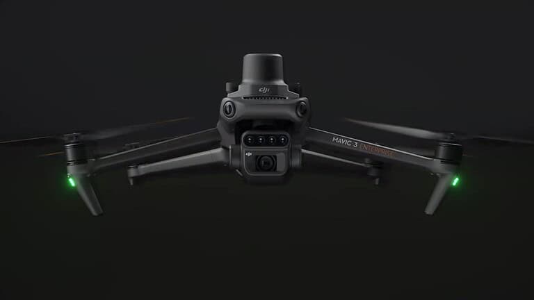
The Mavic 3 Multispectral (Mavic 3M) is a highly integrated, portable drone designed to make the “invisible” visible. By combining a professional RGB camera with a four-band multispectral imaging system, it provides the precise data needed for crop health monitoring, natural resource surveys, and high-accuracy aerial mapping.
- Integrated Imaging System: Combines one 20MP RGB camera with four 5MP multispectral cameras (Green, Red, Red Edge, and Near-Infrared).
- Precision at Scale: Complete mapping operations for up to 200 hectares (approx.4 500 acres) in a single 43-minute flight.
- Centimeter-Level Accuracy: Equipped with an RTK module that synchronizes with the camera in microseconds for survey-grade results without ground control points.
Book a Demo Today
See how aerial tech can fit into your workflow—schedule a live demo and get your questions answered by a local expert.